
Faylo:China Hong Kong 4 levels localisation.svg

此 SVG 檔案的 PNG 預覽的大小:705 × 599 ko kasapinang no siyang-su。 o romaay a cyi-si-tu: 282 × 240 ko kasapinang no siyang-su | 565 × 480 ko kasapinang no siyang-su | 904 × 768 ko kasapinang no siyang-su | 1,205 × 1,024 ko kasapinang no siyang-su | 2,409 × 2,048 ko kasapinang no siyang-su | 1,000 × 850 ko kasapinang no siyang-su.
satapangan tang’an (SVG tang^an,tata’ak no laleko:1,000 × 850 syang-su no sya-sing, o tata’ak no tang^an:703 KB)
| kimad |
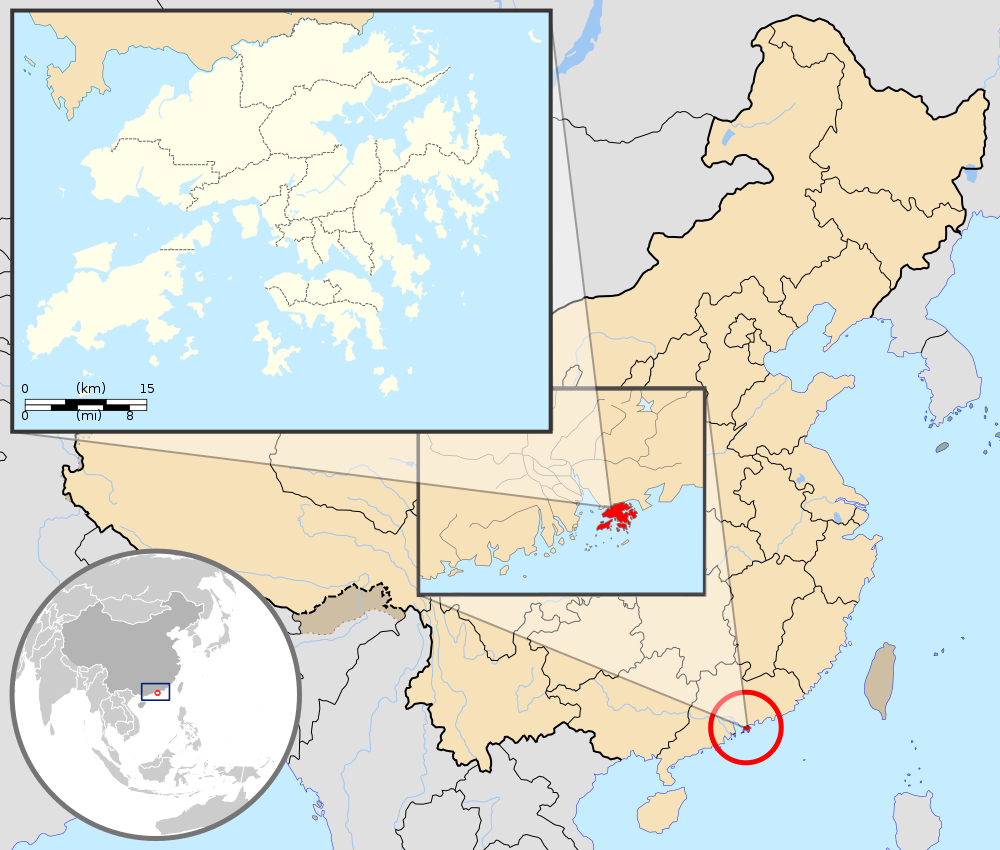
English: Map showing Hong Kong's location in Asia, on China's south coast, and Hong Kong's 18 districts
Français : Carte de Hong Kong : situation en Asie, situation sur le littoral chinois, carte des 18 districts
中文(繁體):顯示香港在亞洲,中國南海岸和香港18區的位置的地圖 |
| O romi’ad | (UTC) |
| lalengatan |
本vector image使用Inkscape創作 . |
| O misoritay |
|
| 其他版本 | 此檔案衍生的作品: Hebao island map.jpg |
| 這是一張修飾過的圖片,即本圖片是用軟體修改過後的版本,修改的方式或內容有:Combination, color correction。原版圖片來源:China Hong Kong.svg。修改者:Pethrus。
|
Nani tiniay i misatapang micokaymas CC konini a tang^an a macokaymas mapasapinang ko ngangan- malecaday pidemak a palada’ 3.0 caay ko no sanoitiniay a demak ko matiliday a rorong o sapipatorod a lawot.
Sakacipinang a pangangan: GFDL
- manga’ay pakonirasa kiso a:
- Mipalada’ – rorod、 patalahekal ato patenak to ninian a nisanga’an
- liyawen a misalof – o nisasaharatengan a nisanga’an
- aka ca piso^do tora ilaenoay a sakarocek:
- Sakacipinang a pangangan – aka ca pido^do^ kiso to nitooran no misoritay ano eca o mihaydaay to sakacipinang a ngangan nikaorira, aka pitakaw a pakafana’ to picokaymas no miso to
- malecaday pidemak palada’ – Ano inian a nisoritan ko sapisomad, sapifalic, ato sapisafaeloh iso a misorit i, onini a rikec ano eca oya malecaday a rikec ko sapicokaymas iso a micowat misanga’ to roma a sorit.[1]
原始上傳日誌
This image is a derivative work of the following images:
- File:Hong_Kong_Location.svg licensed with PD-self
- 2008-08-27T13:27:11Z Joowwww 1270x640 (234741 Bytes) a few minor tweaks
- 2008-08-27T13:18:03Z Joowwww 1270x640 (234389 Bytes) new version: more detailed, colours are standard with most other locator maps
- 2008-04-20T13:54:51Z Joowwww 1270x640 (79729 Bytes) reduced height, removed map border and added rivers and hk's maritime border
- 2008-04-09T11:31:22Z Joowwww 1270x977 (66085 Bytes) {{Information |Description=A map showing Hong Kong's location in Asia, in China and on China's south coast. |Source=self-made |Date=2008-04-09 |Author= [[User:Joowwww|Joowwww]] |Permission={{PD-self}} |other_versions= }} {{Cr
- File:Map_of_Hong_Kong_18Districts_ZH.svg licensed with Cc-by-sa-3.0, GFDL
- 2008-07-05T21:14:26Z Moddlyg 1454x1083 (381097 Bytes) == Summary == {{Information |Description={{en|1=Map of Hong Kong & 18 Districts (Chinese Version)}} |Source=Own work by uploader |Author={{User:Moddlyg/Sign}} |Date=2008/7/6 |Permission= |other_versions= }} {{ImageUpload|ful
- 2008-07-05T20:59:35Z Moddlyg 1454x1083 (262750 Bytes) {{Information |Description={{en|1=Map of Hong Kong & 18 Districts (Chinese Version)}} |Source=Own work by uploader |Author=~~~ |Date=2008/7/6 |Permission= |other_versions= }}
- File:China_Hong_Kong.svg licensed with PD-self
- 2008-08-13T16:22:08Z Joowwww 1000x850 (212124 Bytes) added missing laos/vietnam border
- 2008-05-14T11:14:46Z Joowwww 1000x850 (210515 Bytes) {{Information |Description=An SVG map of China with Hong Kong special administrative region highlighted and circled Legend:[[Image:China map legend.png]] |Source=self-made; based on CIA public domain maps: *http://www.lib.ut
Uploaded with derivativeFX
o likisi no tang’an
pili’en a mimi^mi ko romi’ad/ tok, ta misongila’ a minengneng to tang’an rorong nora tatokian
| O romi’ad/ toki | nisamamangan a conga | o tata’ak ato karaya’ | micokaymasay | pipatongalan to sowal | |
|---|---|---|---|---|---|
| Aniniay/imatinaay | 2019年9月23日 (tinocay) 05:33 | | 1,000 × 850(703 KB) | En rouge | added map scale, for the higher resolution sub-picture |
| 2015年5月14日 (四) 15:57 |  | 1,000 × 850(686 KB) | Flappiefh | Fixed colour of Haïnan. | |
| 2010年3月6日 (六) 02:40 |  | 1,000 × 850(685 KB) | Pethrus | {{Information |Description={{en|1=Map showing Hong Kong's location in Asia, on China's south coast, and Hong Kong's 18 disctricts}} {{fr|1=Carte de Hong Kong : situation en Asie, situation sur le littoral chinois, carte des 18 disctricts}} |Source=*[[:Fil |
sakatayal no tang’an
Onini laenoay makakafit ko felihtayi tonini a tang^an:
O laleko no tang^an i po:long no micokaymas
i kalaenoay oya no roma a wiki micokaymas tonini a tang^an :
- O demak to picokaymas no as.wikipedia.org
- O demak to picokaymas no azb.wikipedia.org
- O demak to picokaymas no bh.wikipedia.org
- O demak to picokaymas no bo.wikipedia.org
- O demak to picokaymas no br.wikipedia.org
- O demak to picokaymas no cbk-zam.wikipedia.org
- O demak to picokaymas no dty.wikipedia.org
- O demak to picokaymas no dz.wikipedia.org
- O demak to picokaymas no en.wikipedia.org
- O demak to picokaymas no fi.wikipedia.org
- O demak to picokaymas no fr.wikipedia.org
- O demak to picokaymas no fr.wikinews.org
- O demak to picokaymas no fr.wiktionary.org
- O demak to picokaymas no fur.wikipedia.org
- O demak to picokaymas no gcr.wikipedia.org
- O demak to picokaymas no gn.wikipedia.org
- O demak to picokaymas no incubator.wikimedia.org
- O demak to picokaymas no io.wikipedia.org
- O demak to picokaymas no it.wikipedia.org
- O demak to picokaymas no ja.wikipedia.org
- O demak to picokaymas no li.wikipedia.org
- O demak to picokaymas no lld.wikipedia.org
- O demak to picokaymas no lo.wikipedia.org
- O demak to picokaymas no mad.wikipedia.org
- O demak to picokaymas no mai.wikipedia.org
misongila’ a minengneng tona matongal ko hekal to picokaymas no tang’an